This is “Work-in-Progress”, which will be added to as and when we come across something interesting about Risan or its environs. Where we have drawn from other sources, these are shown; otherwise these are our own observations. ContentsRisan locationRisan climate Rainfall. Winds. Sunshine.
Our Own Experience 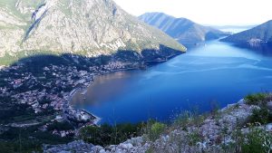
Risan historyArchaeology
The NameSight-seeing
Pot Holes/ Caving
Miscellany
Cultural attitudes
Risan location
42º 30’ 52”N, 18º 41’ 42”E.
The town lies on the shore at the northern end of the Bay of Kotor or Boka Kotorska in Montenegrin. Surrounded on three sides bymountains, it faces south. Apart from a narrow flat strip along the shore, the town is built on sloping ground. About a kilometre from the shore building stops, as the slope changes dramatically into the sheer sides of the mountains. Alarmingly, a road winds its way 600m up this precipice, taking one to the village of Lednice, and from there into the interior -Grahovo and on to Nikšić. Meeting a bus or a lorry on this road is a hazardous procedure, especially if one is on the outside –the drop is vertical and the road was built barely wide enough for one modern vehicle. A wider road has been built with a gentler incline starting around the Bay at Morinj, which links the coast with the interior. It is now fully open to Vilusi, on the road between Nikšić and close to the Border Crossing to Trebinje in Bosnia. When we first came to the Boka in 2007, we were told that the road would be ready the following year, but we had to wait a further 3 years. 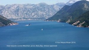
Still that’s not too bad for the Balkans! Around to the west from Lednice is the village of Crkvice (940m above sea level), which is the wettest place in Europe. The average annual precipitation for the period 1931-1960 was 4927 mm/m² and for 1961-1990 4631 mm/m². The highest amounts per year surpass 7000 mm/m² with an all time historic high at 8036 mm/m² (1937). We would guess that some subsequent winters may have surpassed that, but we have not found more up-to-date statistics. Risan from the sea, showing Teuta’s fortress on the left above the last buildings. The ghastly concrete building on the right is the 1970s Hotel Teuta, making a firm statement View to the north-west from our land showing the scar of the new road up the hillside.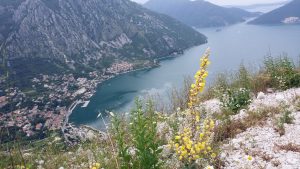
About 1km west along the coast from Risan the road rises around a small bluff on the inside of which is the outflow of one of the two main underground rivers in the Bay. This one is called Sopot and erupts shortly after a major rainfall in the mountains above. It is truly a magnificent sight, with hundreds of tonnes per second of water rushing literally straight out of the mountainside and plunging 20m into the bay. about ‘modern’ architecture.
The second one is called Ljuta and is next to the Stari Mlini restaurant between Orahovac and Dobrota, halfway from Risan to Kotor. Equally spectacular, there the outlet from the mountain is almost at sea level. (I had originally thought that the word for the type of outflow was Sopot and applied it to both Sopot and Ljuta. We were corrected by a local friend; in fact Sopot is the name of the river (as is Ljuta).There are other rivers/ springs which emerge under the water of the Bay, of course, as is common in limestone country. Friends of ours with a house on the bank of Lake Skadar draw their drinking water from one.

Rainfall [mm/m²] (per Wikipedia)
b. Winds
There are two major winds: the Bura and the Jugo. The cold Bura blasts down from the mountains, and gusts can reach 250km/h. From the south (as per its name) comes the humid and wet Jugo.The combination of sea and mountain means that there is a breeze of some kind most of the time. The area is particularly healthy, hencewe assumethe old folks’ homejust down the road from us.(Opposite it, there is a hospital specialising in orthopaedic surgery with very competent doctors though the physical facilities are somewhat antiquated!)
Risanand Neighbourhood
c. Sunshine We are in July 2017 now, and it is hot, so very hot going on for 37 degrees C.
There is a most useful set of sunshine data from the European Commission’s Joint Research Centre, based in Ispra, Italy. It gives monthly data for:Irradiation on horizontal plane (Wh/m2); Irradiation on optimally inclined plane of 34 (Wh/m2); Irradiation on plane at angle of 90deg. (Wh/m2); Optimal inclination (deg.); Ratio of diffuse to global irradiation (-); Average daytime temperature (°C); 24 hour average of temperature (°C); and Number of heating degree-days (-). The annual irradiation at 34°C is 4670 Wh/m2.On our land, we get sun in summer from about 07:30 to 18:00, and in winter from about 09:30 to about 16:30.
d. Our Own Experience
Winters are cold and wet -we’ve had temperatures close to zero in January and February. On the other hand when the sunis around, it can get up to the mid/ high teens. There is an annual mimosa festival in Herceg Novi in early February -but then HN does get appreciably more sun compared to Risan as it is in the outer bay. There was an exceptionally bad winter in 2014/ 2015, when we had several days of temperatures at or below zero –needless to say it resulted in severe damage to our plants which are not used to such poor conditions.Summers are hot and dry, especially of course August when the thermometer goes above 40. Basically summer is from May to October and winter from November to March, give or take a week or two. Spring and autumn don’t really exist! As with so much of life in the Balkans, one goes from one extreme to the other.
The climate data above give July as the highest daytime temperature of 25.0°C, with the 24-hour figure being 23.5°C. August is not far behind at 24.5°C & 23.1°C respectively. January is the coldest month at 5.8°C and 4.8°C. These are of course averages! At any time of the year, thunderstorms erupt. Sometimes for hours, sometimes just passing through. In any case, the drainage system on the roads usually fails to cope, so one finds oneself driving through floods. Another point is that the power system is fragile so thunderstorms can cause power-outages -but then these can happen anytime anyway for no apparent reason.We are highly amused when we watch weather forecasts for northern Europe and hear grave warnings of rainfall of 1cm! We get at least 20cm, usually more, in a really good downpour.Risan history(per Wikipedia)“The earliest mention of Rhizondates back to 4 BC, when it had been the main fortress in the Illyrian state where Queen Teuta took refuge during the Illyrian Wars. During her short reign, Rhizon became the capital of her empire. In Roman times, Rhiziniumis documented as an oppidum civium Romanorum. Two Roman routes led through the Bay of Kotor. The most prosperous time for Roman Rhizinium came during the first and second centuries. Five mosaics are the most valuable remains of that period -not only for Risan but also for Montenegro.
One of the Risan mosaics (not Hypnos) The best preserved one shows Hypnos, the Greek deity of dreams. It is the only known image of this kind in the Balkans.The invasions of the Avars and Slavs left Risan deserted. The last reference of a bishop in Risan dates back to 595. In the 10th century, the Byzantine emperor Constantine Porphyrogenitus includes Risan among the inhabited towns of Travunia, while the priest of Doclea considers Rissenato be a district.During the Middle Ages, Risan lost the significance it used to have in the ancient times. In the mid 15thcentury, Risan was referred to as the town of Herceg (duke) Stjepan. In 1466, the Venetians offered to give Bračisland and a palace in Split to Herceg Stjepan, in exchange for his two towns (Risan and Novi) in the Boka Kotorska. In 1482, the Turks took Risan, together with Herceg Novi, from Herceg Stjepan’s son Vlatko. Only in 1688 Risan became Venetian as part of the Albania Veneta with the Venetian name of Risano.’The northern part of the region was handed to Austria as part of the settlement of the Congress of Vienna in 1814, taking over from Napoleonic control. A few km along the coast towardsMorinjat Lipcithere are prehistoric rock carvings, depicting deer and geometric patterns.”Archaeology
Risan and Neighbourhood Page 6 of 10 various teams of archaeologists have explored the town and the surrounding area. In the 1870s, the famous British archaeologist Sir Arthur Evans, the discoverer of the Mycenaen site at Knossos, referred to ‘the foundations of houses, including a mosaic pavement, to be seen about half an hour up the mountainous steep on the East and near a delicious fountain’. Clearly this is not the same as the mosaics currently on public display about 100m from the sea. Roman roads, an acqueduct and a Hellenistic grave were still visible across the landscape. Evans’ find of a field strewn with coins enabled him to identify Risan as a mint in the time of Prince Ballaeos. (sources Bradt Montenegro p 144, and Absolute SAStronomy). Since 2001, a team from Warsaw University’s Research Centre for Antiquity of South-Eastern Europehas been excavating at the Carine site near the town centre as well as underwater, directed by Prof Dr Piotr Dyczek. From James’meeting with Professor Piotr Dyczek in Risan July 2010:’According to Professor Dyczek, the Illyrian layers in Risan are so close to the surface because the upper layers were stripped off during the Austro-Hungarian period, and afterwards, to create more level space for building. This meant that there is nothing left from the Hellenistic, Roman, Venetian or later periods. The walls of the ancient fortified town have been found to be about 1km long, and this coupled with the sizes of houses/ rooms already excavated would indicate a possible population of about 1500 to 2000. This was pretty substantial for that time. Traces of the wall have been found near the seawall of the modern Teuta hotel, which is probably the furthest extent seaward. Inland, the wall skirts the retaining wall for the school. The river forms the eastern boundary. Although remains have been found down to 2m below the water table/ sea level, excavating this properly is too costly, as it involves the use of methods to keep the water out of the area under examination. The level sinks by about 3mm a year under normal circumstances anyway, and the major earthquake of 1979 dropped the level by a full metre.In addition to the fortified town at sea level, there is the fortress on the hill above the town, where a full spectrum of eras is present. One find this season was a marble head of a woman showing hair decoration typical of the Hellenistic era. A piece of a marble column with Corinthian design was also found. There are also traces of a shrine. The major find this season was a collection of 4000 coins minted by Ballaios during his reign 190 to 175 or 168BC. The metal (ie silver or bronze) will only be determined after conservation which is taking place in Kotor.’The NameThe official guidebooks and leaflets say that the name comes from the Illyrian tribe Risonti. A local friend told us that the name comes from the type of plant root, rhizome (from the Greek rhizoma), and so is associated with the town as a centre from which trade and other activities spread. Be that as it may, there werecertainly a lot of rhizomous plants on the plotwhen we bought it, which hadspread all over the place!
Sight-seeing
In the centre of Risan, there are the rather sad ruins of the Venetian-era baroque Ivelic palace. From the market square the old street, Gabela, leads up past stonehouses. Its upkeep continued to be financed by the Austrians up to 2014 –100 years after the start of World War 1. The church of St Peter and St Paul, built in 1796, is open for a couple of hours in the mornings. On the edge of Risan going to Perast/ Kotor there is an old monastery, Banja, claimed to have been founded originally by Stefan Nemanja in the 12th century.The present buildings date from its reconstruction in the early 18th century. Up on the old road to Grahovo, near the spring in Smokovac,is the church of St John and St Luke.For those who are fit and willing to do some steep hill-walking on rough ground, Teuta’s fortress, accessed from near the school, gives great views of the town. At Crkvice1000m above sea level, there is a monument to the victory of 1869 against the Austrians who were attempting to enforce compulsory military service. Sadly the inscription (in Cyrillic) has mainly fallen off: A dirt road past the monument leads to a cleared level field with the old stables, very over-grown but with the stalls and hitching rings more or less visible. The hillside behind is paved to collect water in a huge reservoir –we have been told that it used to be tiled, but the tiles have been lifted long ago. The dirt road continues on round to a massive bakery (which is also on the tarmac road) for the Austrians forces garrisoned along the ridge-line, relatively close to two of the forts (Westfort Crkvice / Streza and Ostfort Crkvice/ Kom).It has its own water reservoir underneath the building. We have been told that the bakery produced about 30,000 loaves every day! There are many (47) Austrian forts up in the hills, with military roads linking them. We met an Austrian architect who studied them for his Masters degree, and have a copy of his CD showing all the construction details. Sadly there is almost no published information about them. Seemingly, as they represent an occupying empire, the Montenegrin attitude is to neglect them (at best) or pilfer them (at worst). The Austrian Embassy has marked a series ofhiking/cycling trails from Herceg Novi to Ulcinj along the hills. As there are no hotels,let alone cafes or restaurants,up there hikers have to descend to the coast to eat and sleep.
The Bakery Fortress Streza from the Bakery About 2km from Risan, Perast is a lovely little Venetian-style town with most of its original stone buildings well restored. See http://adriatic club.tripod.com/businesscard/id9.html for more details. Sveti Djordje on the left, Gospa od Skrpjelaon the right Perast from Gospa od SkrpjelaIn the Boka just off Perast there are two islands, each with a monastery on it -Sveti Djordje (Benedictine and not open to the public) and Gospa od Skrpjela (open to the public). The Benedictine island used to be the burial place for Perast. Gospa od Skrpjela is man-made from rocks dropped into the water. Every year on 15 August (the Day of Assumption or Dormition of the Holy Mother of God) a procession of boats sets out from Perast to drop more rocks into the water around the island. Small ferry services operate from Perast.At the southern end of the Boka, Kotor is one of the main tourist destinations in Montenegro. Cruise ships call daily during the summer. The multi-walled Old Town is a lovely maze of cobbled streets. Anyone fit enough can climb up thelongest wall surrounding the town to the castle above (take plenty of water, wear strong walking shoes/ boots, and don’t try it during the heat of the day).
For nature lovers, the Orjen range (highest point 1894m) is an amazing wilderness area with forests and plant life waiting to be found. We have still to get up there to do some serious exploring, as one needs either a battered 4×4 or a mountain bike to traverse the tracks. The Kameno Moreor ‘stone sea’ is an accurate description of this typical karst landscape. Our local doctor friends say that the area is rich in medicinal plants.There used to be a factory in Risan, part of a Yugoslav-wide concern, producing herbal medicines from the plants in the mountains. Sadly during the privatisation bonanza after the fall of the Communist system, it got sold to a rival company who closed it, resulting in the loss of many local jobs. The site (behind the EKO filling station) has been sold to foreign investors seemingly for holiday apartments which have yet to materialise.
Pot Holes/ Caving
As one might expect from limestone terrain, there are a mass of underground caves, tunnels, water-courses etc. A British group of pot-holers came out in 2009 and returned in July 2010 to explore the caves in the Kameno Morenear Ledenice. James contacted the group organiser Chris Bindingwho sent him the note before the 2010 expedition:” … We’re a 12 strong team this year (8 strong in 2009) and have two prongs to our expedition; firstly is a revisit to an “unfinished” cave, insofar as there’s more of it than we had time to explore and it has massive potential to yield far more passage, depth and water than we’ve found so far. Secondly, about half the team intend to do a lot of surface prospecting; …we have a few other caves to descend which we found last summer, too. In all, the exploration work has been going on since 1999, with expeditions in 2003, a UK-involved team in 2004, and then again in 2009. The momentum has been building up, largely offthe back of the main cave which we’ve descended to around -400m with another 300m depth potential (to the water table/ resurgence in Risan Bay). The outflow is huge so there’s a subterranean river system down there somewhere, as yet unlocated. We have a strong team of rope technicians and some highly experienced veteran expeditioners, too, with a good background in science, surveying, photography etc. …We expect the cave (named PT4) to lead down to a subterranean river which (most likely) re-emerges at Sopot and/or Spila in Risan Bay. From a caver’s point of view Kameno More is FANTASTIC! A follow-up note from Christopher after theirexpedition in July 2010:”… Firstly, our main push was 99% successful insofar as we have confirmed the cave, PT4, as the 7th deepest in Montenegro, adding a further 4 vertical drops to the system and approximately 130 metres of surveyed depth; since 2009 the surveyed length of the cave has increased six-fold as a result of the team’s efforts. More significantly we have a good archive of photographs and film of this year’s work and this will form a presentation to the UK National Conference in September: once I have edited/finished the film I shall gladly upload it so you can view the kind of stuff we’ve been up/down to! The cave “ended” at a sump (submerged/underwater passage) and plans are already afoot to return with cave divers but that’s going to be a more logistically demanding trip so don’t “hold your breath” waiting for fast results. We did not find the huge subterraneanriver system feeding Sopot/Spila so there’s plenty to play for.
Risanand NeighbourhoodPage 10of 10Surface recce team members also located a number of exceptionally promising sites with similar features to PT4 so there’s masses more scope for Montenegrin caving exploration. …”MiscellanyWe draw our drinking water from a spring up the old road to Grahovo, with a magnificent view over the town and across the northern part of the Boka. The water is delicious -would cost a packet in western European supermarkets! The area is called Smokovac, from ‘smokva’, a fig-tree, due to the number of fig trees which grew there. Nowadays, the main trees are olives -sadly rather dilapidated because (we are told) the owners can’t be bothered to harvest them!
Cultural attitudes
James cannot resist inserting a note or two on cultural attitudes.
a. Smoking. Visitors to the Balkans generally will note that most people are heavy smokers, and underneath non-smoking signs in restaurants there will be usually be an ashtray over-flowing withbutt-ends.
b. Noise. Another aspect for northern European visitors is the volume of conversation. A quiet discussion between friends will be held so that anyone within a 5m radius can listen in. A more heated discussion, say about footballor water polo (a sport in which Montenegrins excel), could reach up to 10m or more. Music is of course loved by everyone, so that what one person plays has to be heard by as many people as possible. This is especially true of weddings, where the noise radius can reach up to several kilometres;with the natural amphitheatre created by Risan’s geography, this is particularly true here.
c. Driving. James has developed two Rules of Montenegrin Driving.
1. If there is a vehicle in front it is your duty to overtake it, preferably on a blind corner on a cliff road with a 500m drop on one side.
2. If you see a friend you stop and talk to him (note gender!). The winner of this game is the one with the longest queue of vehicles behind him when the conversation ends!d. Mobile phones. Montenegrins have one of the highest per capita numbers of mobile phones in the world. That is more than evident when you see them with one seemingly permanently glued to their ears, whether driving or elsewhere. Perhaps the folk memory of having lived in remote mountains for centuries also explains the volume with which they speak into the device –one wonders why they bother using a phone as they could be heard by the person on the other end easily without it.